Over the past thirty years, the Global Positioning System (GPS) has transformed the way we live. Everything from the satnav systems in our cars to our phones’ location tracking abilities rely on GPS to provide a fast and accurate source of location data, wherever you are in the world.
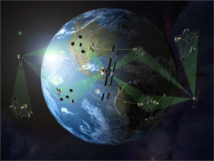
Naturally, surveyors and other location professionals haven’t been immune to the impact of this innovation – quite the opposite. The surveying industry has always embraced the latest technologies – just look at how developments in AI are being incorporated into robotic total stations – and GPS was no different.
Surveyors and location professionals were among the first to see the commercial benefits of the GPS network following its completion in 1995, and GPS surveying methods have since become a popular way to survey larger areas quickly and effectively.
Nevertheless, GPS surveying methods have historically had their drawbacks. Maintaining a consistent and accurate signal isn’t without its challenges, as GPS requires the receiver to establish line-of-sight with at least four satellites in order to establish a position.
Coupled with the relatively limited accuracy of standard GPS measurements and the potential for signal distortion, making GPS suitable for surveying tasks has not been a simple matter.
In recent years, these issues have been tackled head on by the development of surveying equipment that makes use of the entire global navigation satellite system (GNSS) in order to improve accuracy and limit dead zones.
In this post, we’ll look at the development of GPS and GNSS, explain how they function in a surveying context, and look at the advantages of using GNSS surveying equipment.
What is GPS?
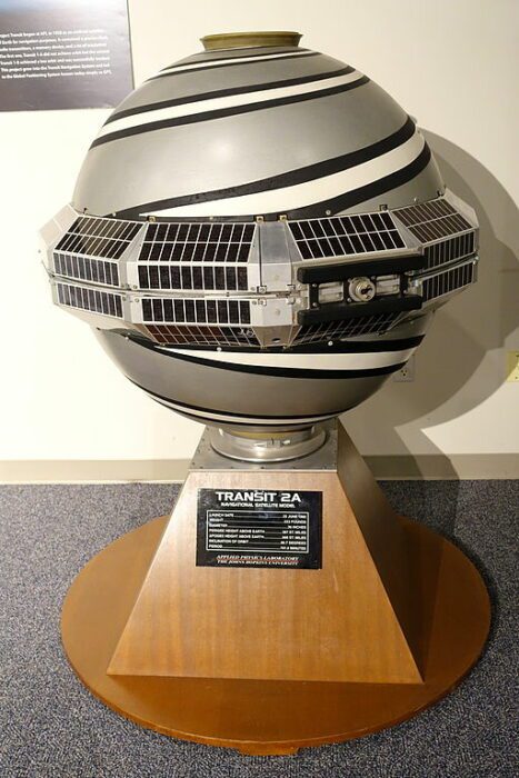
The first satellite navigation system, named Transit
Just like the internet, the Global Positioning System owes its existence to the US military. In the late 1950s, the US Department of Defence began exploring ways to use satellites to provide a fast and accurate navigation system with global reach. Their aim was to improve missile targeting and to assist in the navigation of soldiers and military vehicles. The first satellite navigation system, called Transit, was launched in 1960 and was designed specifically to allow the US Navy to track their nuclear submarines.
The GPS project was formally inaugurated in 1973, with the aim of providing a truly global source of positioning data. This involved launching a constellation of 24 satellites at fixed orbits, each of which would transmit its position and the time using radio signals. This would allow receivers on the ground to measure their distance from the satellite and establish a relative position.
The first satellite was launched in 1978, but it was only in 1993 that the 24th satellite came online and GPS became fully operational in 1995. Despite being designed for military usage, the commercial benefits of GPS were obvious, and as early as 1983 the US announced it would be made available for civilian usage once it was complete.
However, through the 1990s the US embraced a policy of “selective availability”, deliberately reducing the accuracy of GPS outside of a military context. In 2000, this policy was reversed and commercial usage of GPS accelerated.
How does GPS work?
While we don’t need to go too far into the technical details of how GPS works, it’s useful to have a basic idea in order to understand both its benefits and its limitations from a surveying standpoint.
In order to establish its (more-or-less) exact position, a GPS receiver must have line-of-sight on at least 4 of the 30+ satellites that now make up the GPS constellation. 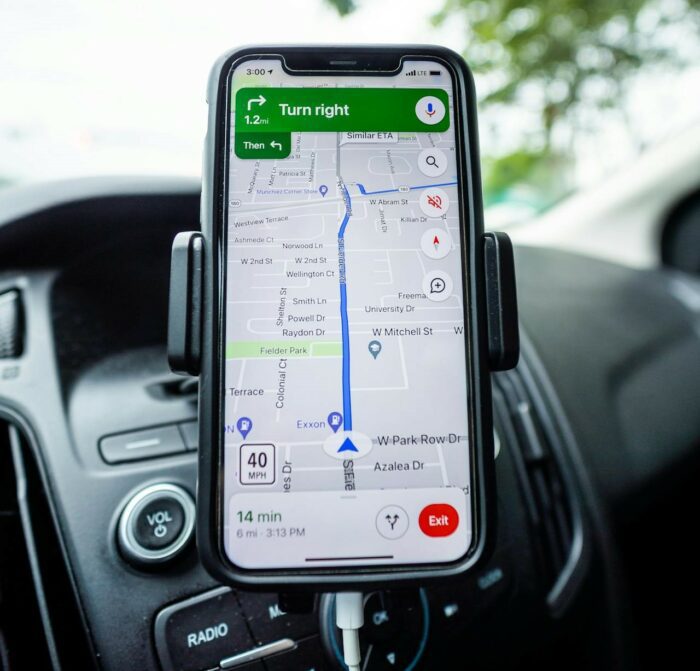 The receiver then uses one signal each to establish its latitude, longitude and altitude, with a fourth to correct any errors in the receiver’s clock. (Every satellite has its own onboard atomic clock.)
However, it must be remembered that these signals are travelling an enormous distance – GPS satellites are orbiting at an altitude of approximately 12,550 miles. As a result, “out-of-the-box” GPS is only able to determine your position within a few metres. As remarkable as this is, it’s insufficient for many applications – surveying foremost among them.
How is GPS used in surveying?
To attain the centimetre or sub-centimetre accuracy required by surveying applications, GPS surveyors use a range of techniques and strategies to augment and refine the GPS signal data.
In the first instance, the GPS technology in surveying tools is significantly more sophisticated than that found in commercial applications such as satnavs and mobile phones. Survey-grade GPS receivers will generally be able to read both of the two frequencies transmitted by the satellites (L1 and L2). They will also often feature sophisticated antennae that can reduce atmospheric distortion and other issues.
In most cases, GPS surveys will also use Differential GPS (DGPS) for increased accuracy and precision. At its core, this approach involves using two GPS receivers to enable error correction between the two. This can be achieved in a number of ways:
- Static baseline setup. A static setup places two receivers at the opposite ends of a line and leaves them for a period of time – the longer the period, the greater the accuracy that can be achieved. By collating the readings between the two receivers, the distortion in each of the signals can be cancelled out.
- PPK or RTK dynamic observation. Alternatively, a static station (the base) can be paired with a mobile station (the rover) affixed to a rover rod. The base is set up on a known position and this is used to correct the position data taken by the rover. This can be done in post-processing (PPK) or in real-time (RTK).
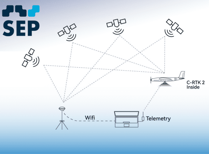
Within these two core approaches, there are a variety of distinct methods and techniques suited to specific applications. For instance, as we’ll discuss below, a virtual reference station can be used instead of a base station for maximum speed and efficiency.
Nonetheless, these strategies, coupled with the advanced technology in survey-grade GPS receivers, allow surveyors and other location professionals to get far more precise and accurate readings than would otherwise be possible.
What are the drawbacks of GPS?
Though GPS is a remarkable technical achievement, it has its limitations. Most of these limitations are related to the challenges of achieving or maintaining a consistent signal from the GPS satellites. In conducting a GPS survey, you may encounter:
- Signal disruption. In urban canyons or areas with dense foliage, establishing the necessary line-of-sight with four or more satellites can be extremely challenging. And if you’re inside a building or underground, it simply won’t be possible.
- Multipath interference. The accuracy of your GPS readings is dependent on the receiver being able to correctly measure the distance the signal has travelled from the satellites. If the signal has reflected off buildings or other objects on its way to the receiver, this can distort the readings.
- Atmospheric effects. Charged particles in the earth’s atmosphere can cause disruption by slowing down the GPS signal as it passes through, impeding the accuracy of your readings.
- Receiver limitations. As we mentioned above, survey-grade GPS receivers are designed to attain significantly higher accuracy than common commercial applications such as phones. That means they are often able to mitigate some of the issues outlined above. Nevertheless, their ability to do this varies depending on specific design and the quality of the components used.
These limitations don’t alter the fact that GPS surveying is an extremely powerful and effective method, particularly when it comes to surveying large open space with relative speed. But there are also ways to further minimise these limitations by using GNSS surveying tools.
What is GNSS?
While GPS was the first global satellite navigation system to reach operational status, it is no longer the only one. In 1995, Russia completed its own system, called the Global Navigation Satellite System (GLONASS). While a lack of funding limited the availability and accuracy of this system through the second half of the 1990s, it has since returned to full operation.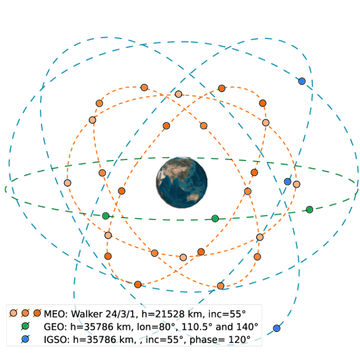
Subsequently, both the European Union and China have established their own GPS-equivalent. The EU began work on a satellite navigation system called Galileo in 2003 and it became fully operational in 2016. China’s alternative, BeiDou, was initially designed for regional usage, but became a truly global system in 2020.
Collectively, these various systems are called global navigation satellite systems, or GNSS. While GPS was the first such system and for quite a while the only effective one, for practical purposes it can now be supplemented by those developed by the EU, Russia and China, as well as by regional navigation systems such as Japan’s QZSS and India’s NAVIC.
Is GNSS better than GPS?
When it comes to choosing between GNSS and GPS for surveying, the difference is essentially between relying on just one satellite system or being able to access all four of the currently operational global services, as well as their regional equivalents. There are a number of major benefits of the latter approach, including:
- Increased signal availability. With multiple different satellite constellations available, GNSS receivers are less likely to experience signal blockages in urban areas or other sites where obstructions are common.
- Improved accuracy. While technically only four signals are needed to establish a position using GNSS, using a larger number of signals can improve the accuracy of readings. As a result, increased satellite availability can also translate into more accurate and reliable positioning data,
- Faster time to first fix (TTFF). TTFF refers to the time a receiver takes to acquire the necessary satellite signals and establish a position. By tracking multiple satellite constellations, GNSS can reduce TTFF and therefore improve the efficiency of your surveying workflow.
Ultimately, there’s no real reason to choose a GPS-only solution over one that can also draw on the full range of GNSS satellite constellations. Opting for GNSS surveying tools will provide extensive benefits, making them well worth the investment.
The future of GPS and GNSS surveying
With four GNSS systems now fully operational, alongside a growing number of regional systems, the speed, accuracy and overall usefulness of GNSS has significantly expanded from its original state in the early 1990s. And there are plans underway to accelerate the pace of improvement even further.
Both GPS specifically, and GNSS systems more generally, are in the process of being upgraded. In recent years, the US has begun to improve the GPS system by launching a new and more advanced set of satellites, a process that will be ongoing through to 2034 and lead to increased accuracy and reliability. The EU is similarly planning to launch a second generation of Galileo satellites through the 2020s.
For surveyors, these ongoing improvements to the GNSS system have been further aided by ongoing advancements in end-user applications and equipment. Let’s take a closer look at some examples of these more recent developments in GNSS surveying tools.
Trimble R12i
At the cutting edge of GNSS receivers is Trimble’s R12i. This advanced solution uses Trimble’s ProPoint positioning engine to seamlessly integrate GNSS signals, data from correction services (such as Trimble RTX – see below) and inertial measurements. 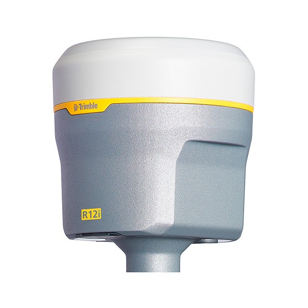 As a result, you can achieve incredible accuracy at pace even in obstructed areas. It also integrates Trimble’s Inertial Platform (TIP) technology to compensate for tilting of the receiver pole, allowing you to achieve high levels of precision in the most rugged and inhospitable terrain.
Trimble RTX
Another key benefit of using an advanced solution like the Trimble R12i is that it can leverage Trimble’s RTX positioning service. This precise point positioning (PPP) service provides real-time corrections to GNSS readings, improving both the speed and reliability of GNSS survey data. With Trimble RTX, accurate GNSS surveys are possible in areas where a conventional base and rover setup isn’t feasible. 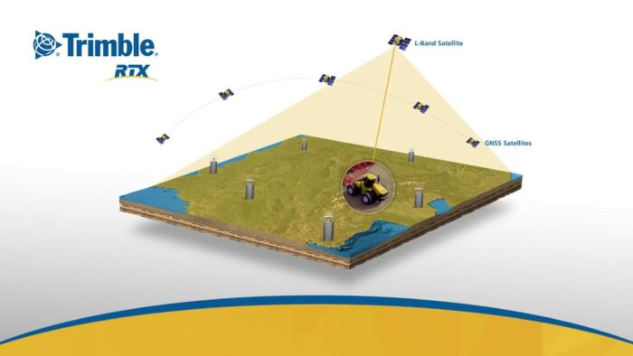
Trimble RTX offers various correction services with different levels of accuracy, so you can choose the solution that best fits your needs. CenterPoint RTX delivers the highest precision for the most demanding applications, while FieldPoint RTX and RangePoint RTX provide varying degrees of accuracy suitable for a broader range of tasks.
Virtual Reference Station (VRS) software
GNSS surveys have also become a significantly faster and more flexible option thanks to the innovation of the Virtual Reference Station (VRS). VRS replaces the need for a traditional base station setup for data correction. Instead, dedicated VRS software combines data from multiple permanently established reference stations to provide real-time corrections, usually via a mobile phone signal.
This approach allows for a large number of readings to be taken over a wider area at a pace that couldn’t be achieved with a base and rover setup. And services such as Trimble’s VRS Now are capable of delivering 2cm horizontal and 3cm vertical accuracy.
Trimble Access
To really see the benefits of using an advanced GNSS receiver, you’ll want to couple it with field software that is designed to take advantage of its most sophisticated features. With specialised modules and automated workflows suited to a range of surveying tasks, as well as powerful data integration and management functionality, Trimble Access can transform your field work. And with the software being continually updated to add new capabilities and quality-of-life features, it will only continue to grow in usefulness.
Trimble Business Center
Once your field work is finished, it’s time to head back to the office and start analysing the data from your GNSS survey. And this is where Trimble Business Center really shines. This office-based counterpart to Trimble Access offers sophisticated data validation and Quality Assurance (QA) tools, as well as surface modelling and point cloud processing functions. Trimble Business Center is a powerful hub for transforming your field data into finished deliverables. It’s designed to handle diverse project types and provides the tools you need for everything from quality control to final presentations.
Choose SEP for your GNSS and GPS surveying needs
GNSS and GPS surveys have become an extremely popular technique – and for good reason. By combining speed and efficiency with the sub-centimeter accuracy enabled by the latest developments in GNSS and GPS surveying equipment, GNSS and GPS surveys are an excellent choice for gathering positioning data across larger sites at pace.
Here at SEP, we’ve been at the forefront of developments in the geospatial industry for over 35 years. We stock a wide range of GNSS and GPS surveying equipment, from GNSS receivers and data collectors to a wide range of useful GNSS surveying accessories.
Feel free to browse our extensive range of surveying equipment, or contact us to discuss your needs with one of our expert team.
