The Global Positioning System (GPS) and other Global Navigation Satellite Systems (GNSS) have transformed surveying practices over the past thirty years. By harnessing a sophisticated network of satellites orbiting Earth, GPS and GNSS technology has helped location professionals replace tedious manual measurements with fast and remarkably accurate location data collection. Surveyors can now rapidly gather data points across vast landscapes, drastically improving project efficiency.
However, GNSS technology isn’t without its limitations. Dense vegetation, deep urban canyons, or even atmospheric conditions can all degrade GPS signal strength, creating data inaccuracies or even “dead zones” where reception is impossible. Additionally, achieving high-precision results often involves setting up and maintaining a base station, adding complexity to your surveying workflow.
Fortunately, Virtual Reference Stations (VRS) offer a powerful solution to the challenges faced by traditional GNSS surveying. By utilising a network of continuously operating reference stations (CORS), VRS eliminates the need for a physical base station while providing real-time correction data to your GNSS rover. This leads to significantly improved accuracy—even in challenging environments—and makes surveying larger areas even faster.
Here at SEP, we have more than 35 years of experience in delivering cutting-edge surveying solutions to location professionals across the world. In this blog post, we’ll explore the world of VRS, delving into its inner workings, compatibility with existing equipment, and the numerous advantages it offers to modern surveying professionals.
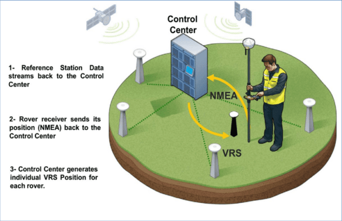
Source Elhattab, Ahmed. (2016). Recent Positioning Techniques for Efficient Port Operations and Development
VRS explained
Virtual Reference Stations (VRS) represent a significant step forward for existing GNSS surveying practices. It acts as a refinement of traditional base/rover setups, using a comprehensive network of reference stations to deliver enhanced accuracy and efficiency over large areas.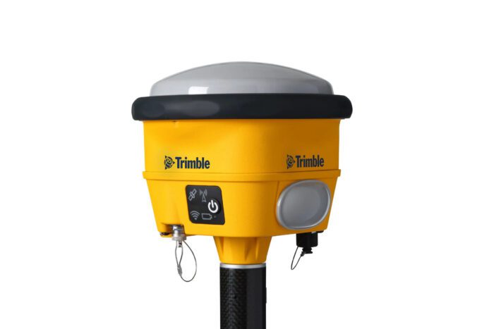
Traditional GNSS surveying usually relies on a two-unit system: a base station and a rover. The base station is a GNSS receiver set up at a known location within the survey area. This base station continuously receives satellite signals and calculates its exact position. Meanwhile, the rover, a portable GNSS receiver, is carried by the surveyor or mounted on a vehicle to collect data points across the site.
To achieve centimetre-level accuracy, surveyors frequently use a technique called Real-Time Kinematic (RTK) surveying. RTK involves the base station calculating the errors affecting satellite signals at that location and transmitting this data to the rover. The rover then uses this information to adjust its own positioning calculations in real-time. However, the range of RTK is typically limited, as it depends on maintaining reliable radio communication between base and rover.
Virtual Reference Stations (VRS) build upon the principles of RTK but expand its capabilities significantly. With VRS, a network of reference stations collects satellite data and calculates their precise positions. These stations then transmit real-time correction data, often over mobile phone networks, directly to your GNSS rover. This removes the need for a physical base station and eliminates the range limitations of traditional RTK, allowing for high-precision surveying over vast distances.
Why do you need VRS?
While RTK surveying offers a leap in accuracy and efficiency compared to basic GNSS methods, it still comes with certain limitations. These limitations can significantly impact your surveying workflow, productivity, and overall project outcomes. Thankfully, however, VRS can tackle many of these issues.
The major limitations of traditional RTK surveying include:
- Accuracy and range. The accuracy of RTK solutions diminishes with distance from the base station, often requiring additional base station setups throughout large project areas.
- Base station issues. Setting up and maintaining your own RTK base station can be time-consuming, and even a small error in establishing the base’s location can translate into significant inaccuracies in the rover’s data.
- Integrity monitoring. Traditional RTK setups often lack comprehensive real-time error-checking. This raises the risk of undetected errors, potentially compromising the integrity of your survey data.
- Dependency. Relying solely on your own base station creates a single point of failure. If the base station malfunctions or loses communication – or if it’s not been fully charged before you head out on a job – your survey work grinds to a halt.
VRS tackles these challenges head-on. By leveraging a CORS network, VRS maintains centimetre-level accuracy over vast distances, extending the capabilities of RTK surveying dramatically. No longer burdened by the need to establish your own base stations, you save significant setup time and minimise potential errors introduced when establishing a base station.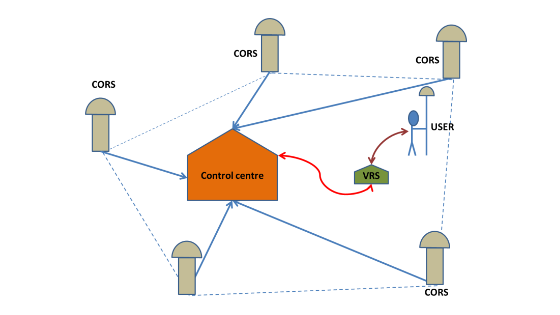
Furthermore, most VRS networks incorporate sophisticated error modelling and integrity monitoring, ensuring the reliability and precision of your survey results. The distributed nature of a VRS network provides inherent redundancy, eliminating single points of failure and ensuring you can continue your survey work uninterrupted.
What level of accuracy can VRS achieve?
VRS is designed to deliver centimetre-level accuracy consistently across the network’s coverage area. However, several factors can influence the final accuracy achieved on-site, including:
- Network density. Denser networks with more closely spaced reference stations lead to better accuracy. This is because denser networks can more finely model the various errors that affect GNSS signals within the network’s coverage area, resulting in more precise corrections for your rover.
- Data transmission. A reliable mobile signal is crucial for receiving VRS corrections in real-time. Interruptions, delays, or weak signals can introduce errors or cause data gaps, reducing accuracy.
- Equipment. Your GNSS rover’s capabilities directly impact the accuracy you can achieve. A high-quality, multi-frequency receiver capable of tracking multiple GNSS constellations (GPS, GLONASS, etc.) will provide better results, especially in challenging environments.
- Atmospheric conditions. While VRS networks significantly reduce errors caused by atmospheric disturbances, severe conditions (like solar storms) can still cause slight variations in signal propagation. The impact of this is usually minimal compared to traditional RTK. However, with solar flares set to reach a peak in 2025, you should consider exploring a service like Trimble’s IonoGuard, which helps to protect against ionospheric disturbances.
It’s important to note that most VRS providers will specify the expected accuracy levels within their network’s coverage area. Before deciding on a VRS service, you’ll want to ensure it can deliver the results you need based on both your accuracy requirements and the location you’ll be working in.
What are the limitations of VRS?
VRS is a fantastic tool for surveyors, but like any tool, it’s important to know when and where it works best. There are a few key factors that can affect the performance of VRS systems, and it may not be the ideal choice for every project.
Key issues to consider include:
- Network coverage. The accuracy and availability of VRS depend on your location being within the coverage area of a reliable network of reference stations. Operating outside of the network’s boundaries will limit its usability. Check with potential VRS providers for detailed coverage maps.
- Mobile dependence. Most VRS systems rely on mobile data networks to transmit corrections to your rover. Poor signal strength or outages can disrupt your workflow and limit accuracy. Some VRS systems offer integrated UHF functionality as a backup for areas with unreliable mobile phone coverage.
- Subscription costs. In order to take advantage of a VRS system, you will likely have to pay a recurring subscription fee to the service provider. It’s important to factor this extra cost into your budget and balance it against the efficiency gains VRS can provide.
The key to getting the most out of VRS is finding the right fit. Take the time to explore different VRS providers in your area. Check out their coverage maps, compare their reliability, and see what kind of support they offer. A little research upfront can pay off in big gains in accuracy and efficiency on your surveying projects.
Trimble’s GNSS surveying solutions
Achieving the desired level of precision in your GNSS surveys depends on finding the right solution tailored to your needs. There’s no one-size-fits-all solution – the best method depends on your unique project needs and circumstances. Thankfully, some companies offer a range of different options for RTK corrections, enabling you to choose the one that best fits your situation.
For instance, Trimble offers a range of solutions for improving the speed, accuracy and reliability of your GNSS surveys:
- Trimble VRS Now is a classic VRS solution. It utilises a network of continuously operating reference stations (CORS) to deliver real-time, centimetre-level accuracy over large areas. It’s ideal for projects within VRS network coverage areas where high precision is crucial.
- Trimble RTX is a PPP (Precise Point Positioning) solution. It receives corrections from satellites, instead of a network of ground stations. RTX offers varying levels of precision globally, making it perfect for remote areas with poor or non-existent mobile coverage.
- Trimble xFill is a backup service to ensure an interruption to your VRS connectivity won’t stall your survey. If your VRS Now (or RTK) corrections are temporarily interrupted due to mobile service issues or radio outages, xFill uses RTX corrections to maintain high accuracy for a short period.
- Trimble GNSS Planning offers extremely helpful information on the status and positioning of satellites from the five core GNSS constellations. This allows you to plan for any situations where specific constellations may be inaccessible from your surveying location, as well as adapting to any disruptions to the health and functionality of specific satellites.
- Trimble Business Centre is an office-based surveying software package that, among its many other functions, allows you to import the Rinex data from the CORS. This can then be used to provide corrections for static or post-processed kinematic (PPK) surveys.
Each of Trimble’s correction services has a number of distinct tiers, with different pricing and degrees of accuracy. That means you can choose the level of service you need depending on your specific use-case – for instance, agricultural applications may benefit from using Centerpoint VRS, rather than VRS Now.
What surveying equipment is VRS compatible with?
The power of VRS lies in its ability to enhance the precision of your existing GNSS surveying tools. But of course, seeing the benefit of this innovation requires having compatible equipment.
Thankfully, most modern GNSS receivers are equipped with the ability to receive and process VRS corrections. Nevertheless, it’s also worth considering the quality and effectiveness of your receiver’s connectivity options. As we mentioned above, VRS uses mobile networks to transmit its corrections – if your receiver’s mobile connection isn’t consistent, you may find you struggle with signal dropouts that slow down your surveys. 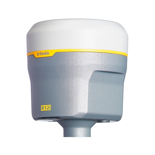
And if you want to explore a PPP solution like Trimble RTX, you’ll want to make sure this is something your receiver can accommodate. While Trimble RTX doesn’t use a mobile signal, instead relying on satellite data, you will need to ensure your receiver is able to receive and process the data RTX transmits.
If you’re looking for a GNSS receiver that is VRS-ready and is also designed with Trimble’s RTX service in mind, the Trimble R12i is a great choice. With its advanced ProPoint positioning engine, it’s extremely effective at integrating correction data. And with Trimble Inertial Platform (TIP) providing calibration-free tilt correction, you’ll be able to achieve accurate measurements in the most challenging conditions.
Choose SEP for your GNSS surveying needs
A VRS system can transform your GPS/GNSS surveying workflow. Without the need to establish a physical base station, you can survey large areas with unmatched speed and without impairing your accuracy.
Nevertheless, in order to get the most out of a VRS system, it’s essential that you choose the right VRS provider for your needs – and that you have GNSS surveying equipment that can make the most of this service.
Here at SEP, we stock a wide range of GNSS surveying equipment, including GNSS receivers and data collectors. And our experts are always on hand to discuss your needs and provide tailored advice on the best solution for you. So if you’re not sure whether a VRS service is the right solution for you, get in touch today.
